
“After the evaluations carried out by the Hydrographic and Oceanographic Service of the Navy (SHOA), the State of Alert For the coastal edge of the regions of Arica and Parinacota, Tarapacá, Antofagasta, Atacama, Coquimbo, Valparaíso (Juan Fernández archipelago), O’Higgins, Maule, Ñuble, Biobío, La Araucanía, Los Ríos and Los Lagos, “they reported.
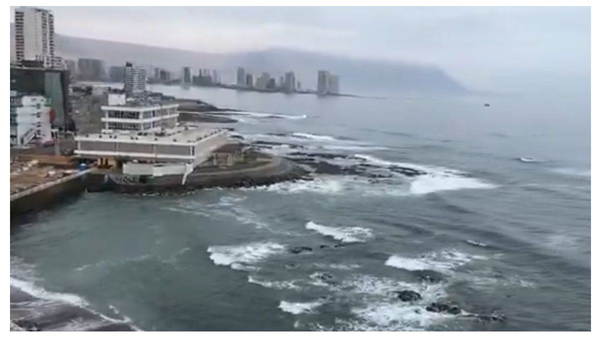
For its part, the town of Quintero He registered the second with the greatest disturbance so far, with 90 centimeters.
They complete the list Columoin the Biobío region, with, an update at sea level of 70 cm, followed by Chañaral and Huascoin the Atacama region; Coquimboand Port Aldeain the Coquimbo region; Valparaísoin the homonymous region, and Constitutionin the Maule region, all with variations of 60 cm, according to SNAM figures.
Where is Kamchatka, the center of the earthquake
Kamchatka is one 1250 km length volcanic peninsula – In the East Russian – and that he enters the Pacific Ocean. The territory records a total area of 472,300 square kilometers and has a multi -ethnic population of approximately 402,500 inhabitants.
The population of the Peninsula is composed of Koriakos, Russos, Koryy-Harams, Chukchi, Itelmenos, Kamchadales, Belarusos, Tartars of the Volga and Ainus.
The peninsula is recognized as One of the regions with the greatest volcanic and seismic intensity of the planet. His Geological activity It is so pronounced that it represents a risk for civil aviation due to the dense ash columns that even today emanate from several of its volcanoes.
The territory is part of what is known as the “Pacific Fire Belt”, a region that houses 90% of The seismic movements of the planet region. Kamchatka, particularly, houses about 30 volcanoes Assets between the approximately 130 that make up its geography.
In addition to the constant volcanic dynamism, the area is the usual scenario of earthquakes. The explanation is in its strategic location: It is located just on the edge of the American tectonic plaque, in contact with the Euroasy and the Pacific, and very close to the Filipina, which makes it one of the most seismic areas of the globe.
The majority of the population lies in Petropávlovsk-Kamchatski, the capital and main port, whose economy is largely supported by the activity of shipyards linked to the fishing industry. The rest of the inhabitants are distributed in small locations along the Peninsula, where they subsist thanks to the fishing – in the special salmon and the well -known Kamchatka crab – and tourism, which in recent years has begun to gain impulse in this remote region.
The natural attractiveness of the territory, with its imposing landscapes, contributed to the fact that in 1997 be added to the list of heritage of humanity. In Kamchatka, glaciers and volcanoes, bubbly hot springs, waterfalls, flowering meadows, snowy fields and rock formations originated in old eruptions.
What is the fire belt, the most unstable area on the planet
An earthquake 8.8 shook Kamchatka’s coasts on Tuesday night, At the eastern end of Russia, generating a tsunami alert for all regions that border the Pacific Ocean. This is one of the most intense earthquakes of the last decades, and figure tied In 12th place among the most powerful ever registered.
The epicenter was located in a subduction zone, where the Pacific plate slides below the American plaque, a process that accumulates geological tension for years. This type of event puts the focus on the Pacific Fire belt, the region with the greatest seismic instability in the world and of which Mexico is also part of.
Also known as Circumpacific ring or belt, This seismic and volcanic belt has an approximate extension of 40,000 kilometers in the form of a horseshoe that surrounds the Pacific Ocean. There they interact some of the main tectonic plates of the planet – among them, those of the Pacific, North America, Nazca, Cocos and the Philippines – that are pressed, sink or slide against each other constantly.
That tectonic dynamic makes the region the epicenter of the greatest geological tensions of the planet: More than 90% of global seismic activity occurs in this beltwhich also houses some 450 active volcanoes. According to the Mexican Geological Service, between 80 and 90% of the seismic energy that is released every year on Earth takes place in this area.
The subduction process is the main mechanism behind the great earthquakes. An oceanic plaque sinks below another continental and accumulates pressure until it is released in the form of earthquakes or volcanic eruptions. Thus the megaterremotos originate, of magnitude equal to or greater than 8, also capable of trigger tsunamis. Historical cases include Chilean earthquake in 1960 (M9.5) and Thoku’s earthquake in Japan, in 2011 (M9.0). The recent movement in Kamchatka occurred in one of these critical areas, between the Pacific and North American plates, which explains its intensity. Despite its power, it occurred far from large urban centers.
Source: Ambito


