Image: (Volker Weihbold)

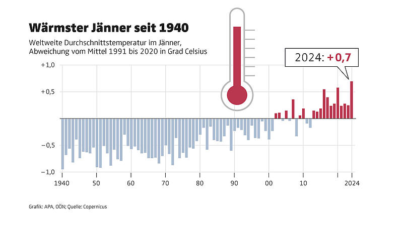
The European Union’s climate change service Copernicus announced this on Thursday. At an average of 13.14 degrees Celsius, the air temperature on the earth’s surface was 0.7 degrees higher than the average for the reference period from 1991 to 2020 and 0.12 degrees higher than the highest January temperature so far in 2020.
- Also read: 48.8 degrees: Europe’s new scientifically confirmed heat record
“2024 starts with a record month – not only is it the warmest January ever recorded, but we have also just experienced a twelve-month period of more than 1.5 degrees above the pre-industrial reference period,” said Copernicus Deputy Director Samantha Burgess. Rapid reductions in greenhouse emissions are the only way to stop rising global temperatures, she warned.

1.66 degrees higher than average temperature
The data used by Copernicus goes back to 1950, but some earlier data is also available.
The mean temperature for January 2024 was also 1.66 degrees higher than the estimated average temperature for this month in the period between 1850 and 1900. According to the information, the global average temperature for the past twelve months from February 2023 to January 2024 was also as high as never before. It was 0.64 degrees higher than the reference period from 1991 to 2020.
- On the subject: Gloomy forecast for the ski areas in Austria
A mixed picture emerged in Europe. While it was significantly cooler in the Nordic countries than the average for the reference period, it was significantly warmer in the south of the continent. Temperatures were also above average in eastern Canada, northwest Africa, the Middle East and Central Asia, while temperatures were colder than average in western Canada, the central United States and most of Siberia.
Unusually high level continues
The El Niño weather phenomenon has begun to weaken in the equatorial Pacific, but air temperatures over the sea remain at unusually high levels, the Copernicus statement continued. The recurring weather phenomenon heats up the Pacific every few years.
- You might also be interested in: This year, too, the “doomsday clock” is 90 seconds before midnight
The European Union’s climate change service Copernicus regularly publishes data on surface temperatures, sea ice cover and precipitation. The findings are based on computer-generated analyzes that incorporate billions of measurements from satellites, ships, aircraft and weather stations around the world.
My themes
For your saved topics were
new articles found.

info By clicking on the icon you can add the keyword to your topics.
info
By clicking on the icon you open your “my topics” page. They have of 15 keywords saved and would have to remove keywords.
info By clicking on the icon you can remove the keyword from your topics.
Add the topic to your topics.
Source: Nachrichten


